
Strait of Gibraltar
The narrow maritime gateway between the Atlantic Ocean and the Mediterranean Sea
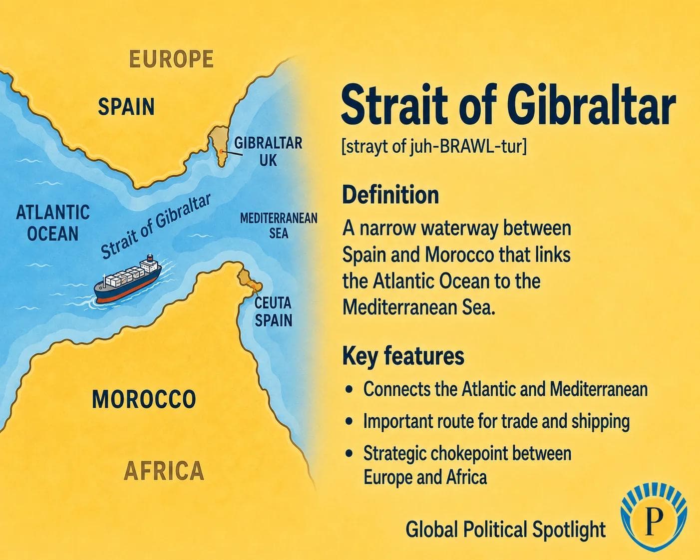
The Strait of Gibraltar is a narrow waterway between Spain and Morocco that connects the Atlantic Ocean to the Mediterranean Sea and serves as a major global shipping chokepoint.
Definition
The Strait of Gibraltar is the narrow waterway that connects the Atlantic Ocean with the Mediterranean Sea. It lies between southern Spain and northern Morocco, with the British Overseas Territory of Gibraltar located on the northern side near the entrance to the Mediterranean.
At its narrowest point, the strait is about 14 kilometers wide, making it one of the world’s most geographically concentrated maritime passages. It is used by commercial ships, energy cargoes, naval vessels, ferries, fishing fleets, and migration routes between Europe and Africa.
The strait is strategically important because it controls the main sea entrance to the Mediterranean. Access through it links Atlantic trade routes with Mediterranean ports, the Suez Canal route, North Africa, Southern Europe, and naval operations across several regions.
Why It Matters
The Strait of Gibraltar matters because it is a maritime chokepoint where geography concentrates trade, energy flows, naval mobility, migration pressures, and border management. Disruption or instability around the strait could affect shipping between the Atlantic and Mediterranean.
The strait also matters for European, North African, NATO, and Mediterranean security. Its location connects Spanish, Moroccan, British, and wider EU interests, while its shipping lanes make it relevant to port security, maritime surveillance, customs enforcement, search and rescue, and naval access.
GPS should track the Strait of Gibraltar as a strategic maritime chokepoint linking the Atlantic, Mediterranean, Europe, North Africa, and the Suez route. The key analytical issues are freedom of navigation, port and naval access, Spain-Morocco-UK relations, Gibraltar’s status, migration and border management, energy flows, maritime security, and resilience of Mediterranean trade routes.
Key Facts
- Type
- Maritime chokepoint
- Location
- Between southern Spain and northern Morocco
- Connects
- Atlantic Ocean and Mediterranean Sea
- Narrowest width
- Approximately 14 kilometers between Europe and Africa
- Nearby territory
- Gibraltar, a British Overseas Territory, sits near the northern entrance to the Mediterranean
- Strategic role
- Controls the main western sea entrance to the Mediterranean
- Maritime relevance
- Important for container shipping, energy cargoes, naval movement, ferries, fisheries, and port access
- Security issues
- Maritime surveillance, migration management, smuggling, naval access, and Gibraltar-related diplomacy
FAQ
What is the Strait of Gibraltar?
The Strait of Gibraltar is a narrow waterway between southern Spain and northern Morocco. It connects the Atlantic Ocean to the Mediterranean Sea and is one of the world’s most important maritime chokepoints.
Why is the Strait of Gibraltar strategically important?
It is strategically important because it controls the main western entrance to the Mediterranean Sea. Commercial shipping, naval vessels, energy cargoes, ferries, and regional trade all pass through or near the strait.
Who controls the Strait of Gibraltar?
No single state controls the entire strait. Spain and Morocco border it, Gibraltar is a British Overseas Territory on the northern side, and international navigation rights are central because the strait connects two major bodies of water.
How wide is the Strait of Gibraltar?
At its narrowest point, the Strait of Gibraltar is approximately 14 kilometers wide between Europe and Africa.
How does the Strait of Gibraltar affect trade?
It allows ships to move between Atlantic routes and Mediterranean ports, including routes connected to Southern Europe, North Africa, the Suez Canal, the Middle East, and Asia. Its location makes it a key logistics gateway.
What are the main security issues around the Strait of Gibraltar?
Security issues include maritime surveillance, naval access, migration and search-and-rescue operations, smuggling, port security, Gibraltar-related diplomacy, and the protection of shipping lanes.
Recent Developments
Spain, the UK, and EU continued Gibraltar post-Brexit arrangements
Negotiations over Gibraltar’s post-Brexit relationship with the EU continued to highlight the strait’s connection to border management, sovereignty sensitivities, mobility, and regional economic ties.
Government of GibraltarMediterranean shipping remained exposed to wider chokepoint risks
Disruptions around the Red Sea and Suez route increased attention on Mediterranean shipping resilience, reinforcing the role of the Strait of Gibraltar as the western entry point to Mediterranean maritime networks.
International Maritime OrganizationSources6 references
- Encyclopaedia Britannica
Reference overview of the Strait of Gibraltar’s geography and connection between the Atlantic and Mediterranean.
- International Maritime Organization
Institutional reference on ships’ routeing, navigation safety, and maritime traffic management relevant to major straits.
- United Nations Convention on the Law of the Sea
Primary legal reference for international law of the sea, including transit passage through straits used for international navigation.
- Government of Gibraltar
Official source for Gibraltar’s government, public policy, and territorial context at the entrance to the Mediterranean.
- NATO
Institutional reference on NATO maritime security, relevant to naval access and security in the Mediterranean and Atlantic approaches.
- European Border and Coast Guard Agency
Institutional source relevant to European border management, migration routes, and maritime surveillance around the western Mediterranean.
GPSNews App
Read GPSNews on iPhone
Daily geopolitical briefings, government updates, and prediction signals in one focused app.
Newsletter
Stay Ahead Of The Next Signal
Get briefings in your inbox when new analysis and reports are published.